


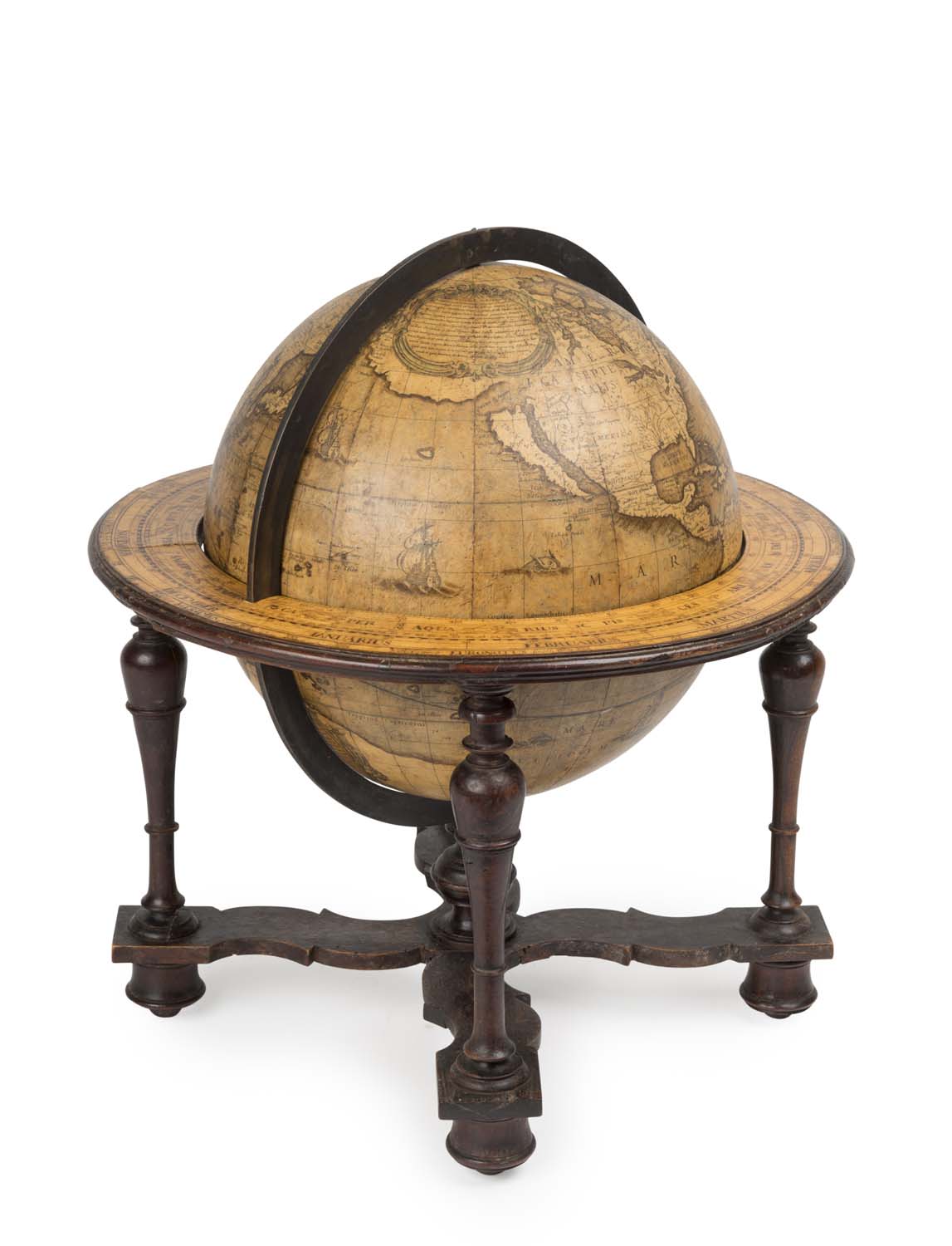
Lot #246 - GREUTER, Matthaeus / ROSSI, Giovanna Battista - 1638 Terrestrial Globe
-
Auction House:Mossgreen
-
Sale Name:International Decorative Arts
-
Sale Date:08 May 2017 ~ 6pm
-
Lot #:246
-
Lot Description:GREUTER, Matthaeus / ROSSI, Giovanna Battista - 1638 Terrestrial Globe
UNTITLED (Si Stampa da GIO: Batta de Rossi Milanese in Piazza Navona Roma). Excudit 1638 (at end of dedicatory cartouche).
26.5 cms table globe. -
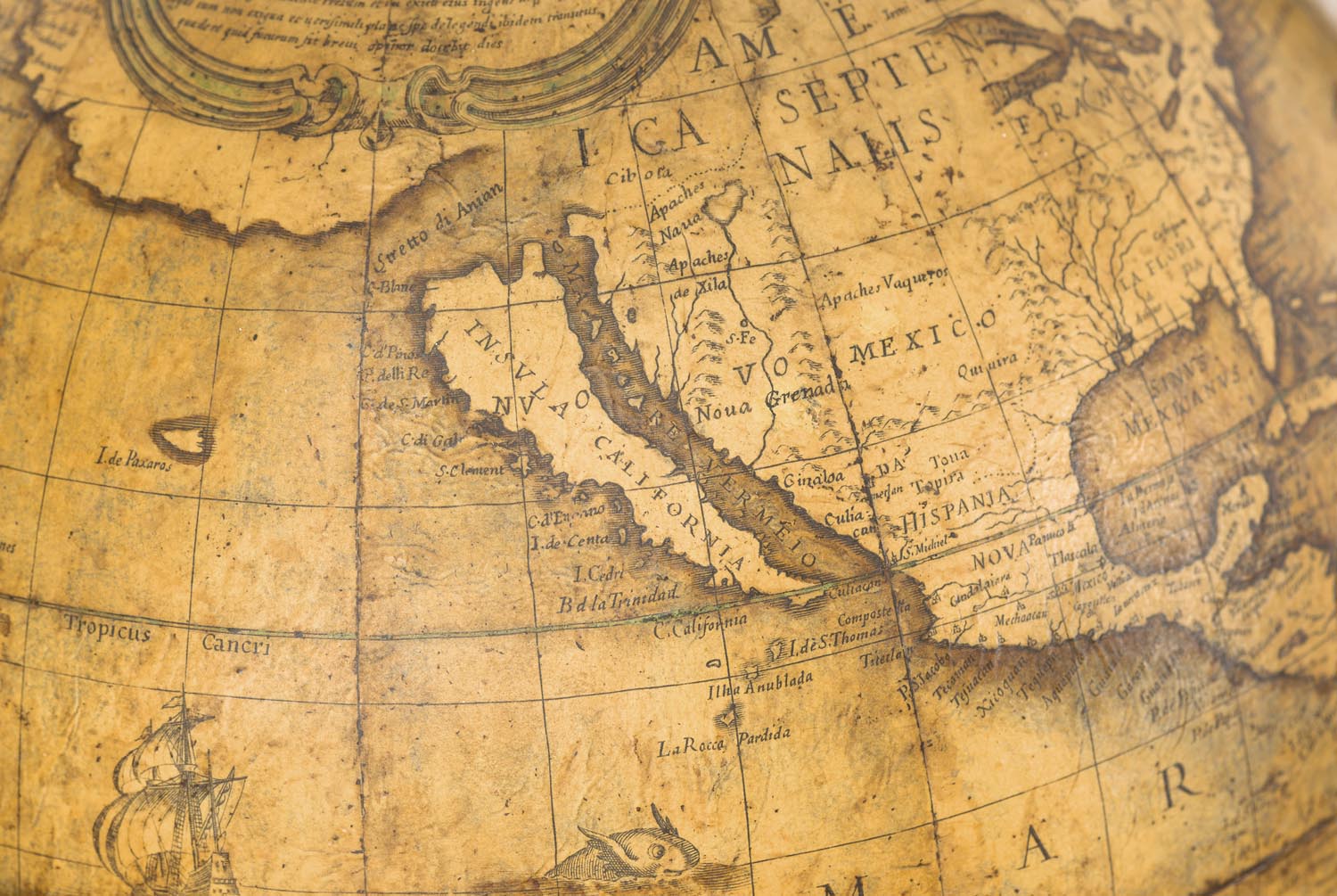
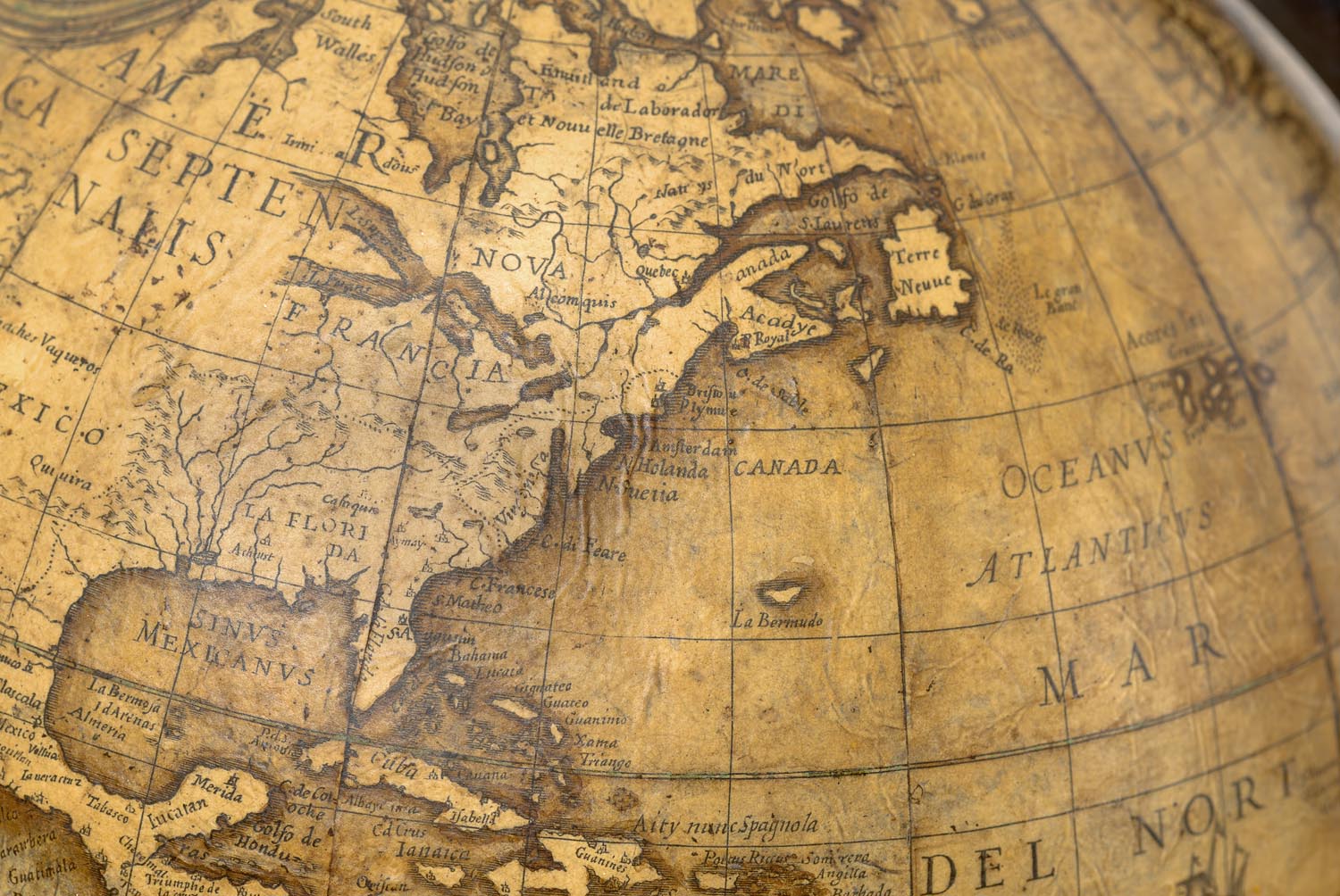
Notes:Twelve copper-engraved full gores in original hand colour clipped at 70°. Two polar calottes are laid to the plaster covered wooden sphere. The globe is mounted in a brass meridian ring, graduated in four quadrants. The wooden horizon ring has a paper ring in a later (but early) manuscript hand, with illustrations of the scales of degrees and the Zodiac, the signs of the Zodiac and eight compass points. The original mahogany furniture consists of four turned, tapered legs connected by two fretwork stretchers. The sphere is supported by a turned central column. Missing is the hour ring, commonly absent in globes of this age. The engraving is clear and the general appearance and condition are very good. Some minor loss here and there expertly restored. Published by Giovanni Battista de Rossi in Rome after 1838. “Excudit Roma 1638.” Only the second recorded example of Rossi’s re-issue of Greuter’s 1638 terrestrial globe. One of the earliest printed cartographic depictions of the Great Lakes in more-or-less their correct form; the first naming of N.Amsterdam (New York) on a globe; the first time Lake Superior is given its current name on a globe. This extremely rare example of Greuter’s terrestrial globe was published in Rome by Giovanni Rossi, following Greuter’s death in 1638. Rossi’s imprint appears on one cartouche while the date 1638 and Greuter’s name are engraved on another. This example is significantly smaller than the other two Greuter globes produced by Rossi that year. Stevenson (“Terrestrial and Celestial Globes” 1921), unaware of this example, notes what he refers to as a “unique” example of this 1638 re-issue in the fine collection of the Hispanic Society of America, still the only other known example. The engraving style, geography and decoration of the Greuter/Rossi globe closely follow that of Blaeu’s 1622 60 cm terrestrial globe (Stevenson fig.97) with a few significant differences, some of which were not noted by Stevenson. Peter van der Krogt (“Old Globes in the Netherlands” 1984) has established that another Greuter/Rossi globe is held by the Maritime Museum of Rotterdam, however the present example differs significantly from both the Rotterdam globe and the larger Greuter/Rossi productions of the same year. Firstly, Greuter names New York (“N.Amsterdam”), perhaps the earliest globe to do so and, secondly, “L.Superior” is named for the first time on a printed globe. Perhaps the most significant difference however between the other Greuter globes and this example, is the latter’s definitive depiction of all five Great Lakes, one of the first clearly recognisable depictions of these important American landmarks and the first on a globe. The other Greuter globes are geographically consistent with Greuter’s 1632 globe and do not show the Great Lakes. We also see on Greuter’s globe an early attempt to delineate the territorial divisions of “Virginia”, “La Florida”, “Nuova Mexico”, “N.Amsterdam” and “N.Seutia”. [Nova Scotia]. Of further note is the graphic portrayal of California as an island. This is a new feature for Greuter globes and quite possibly the earliest such representation on a globe. In stark contrast to Greuter’s up-to-date re-working in North America, his representation of Terra Australis Incognita is anachronistic. Ignored totally are the recent disoveries in Australia, discoveries that had already started to emerge on maps by Hondius, Cloppenburgh and Danckerts/Tavernier. New Guinea’s northern coastline runs paralell with the coast of Terra Australis Incognita as it slopes to the south-east towards South America. Greuter shows it extending far beyond the Solomon Islands. The 1616 voyage by Schouten and Le Maire is noted in several locations from Cape Horn to New Guinea including a notation south of “Terra del Foco” and the charting of “Staten Land”, while above New Guinea “Willem (Schouten) Eyland” is noted. Another area of significance is Greuter’s depiction of the lands north and east of Japan. In a marked deviation from similar maps of the period, Greuter shows a large land mass to the East. This land mass is separated from North America by “Stretto di Anian”. This feature is not found on earlier Greuter globes. Greuter’s depiction of the Strait of Iesso (“Estreito de Ieso”) precedes the first printed depiction of the strait on a world map [Baurand, 1658]. Further new elements of the depiction of the islands of Japan are similarly important. Other features of Greuter’s globe include a graphic depiction of the Great Wall of China and a proliferation of sea monsters and galleons. A more extensive version of this description, together with further reference material, is available upon request.
-
Estimate:A$150,000 - 200,000
-
Realised Price:
-
Category:Scientific & Industrial
This Sale has been held and this item is no longer available. Details are provided for information purposes only.