


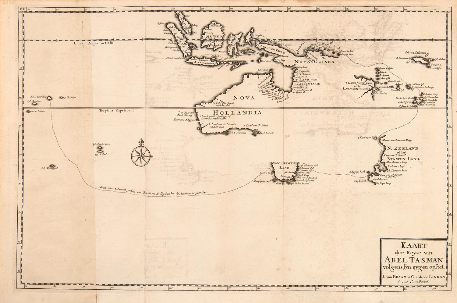
Lot #342 - KAART DER REYSE VAN ABEL TASMAN VOLGENS SYN EYGEN OPSTEL By Braam & Linden
-
Auction House:Mossgreen
-
Sale Name:Australian & Colonial History
-
Sale Date:28 Jun 2016
-
Lot #:342
-
Lot Description:KAART DER REYSE VAN ABEL TASMAN VOLGENS SYN EYGEN OPSTEL By Braam & Linden
[Amsterdam, 1726], map showing the discoveries of Abel Tasman in 1642-43 and 1644, two sheets co-joined
overall 49 x 33 cm -
Provenance:Private collection, Victoria
-
References:Plate from: Verhandeling der zee-horenkens en zee-gewasson in en omtrent Amboina en de naby gelegene ey landen, mitsgardens een naaukeurige beschryving van Banda. Derde Deels, Tweede Stuk / door François Valentyn. Te Dordrech, by Joannes van Braam, Amsterdam, Gerard Onder de Linden, Boekverkoopers, 1726
-
Notes:Another example of this map is in the collection of the National Library of Australia, Canberra; the State Library of New South Wales, Sydney; Harvard Library Map Collection, Cambridge; and the University of Otago, Dunedin Maps, those ever-evolving calligraphic profiles of land masses, represent different ideas for different people. The intrepid traveller clings to it like an indispensable tool that facilitates navigation. The scientist uses it for geological mapping and geographical identification. For the layman it can be an abstract definition of an exotic place or perhaps a fixed symbol of national pride. For governments and trading companies, particularly in the age of discovery and colonisation, the map served the dual purpose of sharing earthly knowledge whilst asserting territorial dominance – proof of their explorations – and exploitations – of distant lands. Between the sixteenth and eighteenth centuries, European powers shuffled to complete the picture of the uncharted Austral world. The Portuguese and Spanish led the way, but it was the Dutch that made great leaps in cartographical records. The history of outsider contact with the Great Southern Land and its charting is a fragmented one. In the 1500s, Makassan fisherman and traders visited Arnhem Land seasonally, however, they never drew lasting maps, nor laid any foundations for a permanent station.1 By the early 1600s, the Dutch East India Company, with its post in Batavia (present-day Jakarta) gradually began making Terra Australis visible on paper. In 1642 the Governor General of the Dutch East India Company, Anthony Van Diemen, in a quest to broaden the Empire’s domain and explore new natural resources and trade, set out the ambitious task of completing the picture and ‘finding the remaining unknown part of the terrestrial globe.’2 Abel Tasman, the skilled navigator, cartographer, and merchant was selected to command this mighty assignment in two separate expeditions in 1642-3 and 1644. This map represents, by way of illustration and inscription, Captain Tasman’s voyage of curiosity and discovery. It outlines the path of his two ships, the Heemskerck and Zeehaen in 1642-3. The company sailed via Mauritius and bypassed the Australian mainland and headed directly to what he would later name Van Diemen’s Land.3 He charted the western, southern and eastern coastlines of this island (believing it was the mainland), before tracing the west coast of New Zealand’s South Island, Tonga, Fiji, before finally returning to Batavia. The map also shows the northern coast of Australia’s mainland which was recorded in Tasman’s second voyage of 1644; the one in which he declared the new continent as Nova Hollandia – a name that would linger for over 150 years.4 Although Tasman was successful in completing major parts of South Pacific puzzle, the mission was considered an unsuccessful one by the Company, as the expedition led to no financially lucrative discoveries. Despite being incomplete, Tasman’s map was distinguished by its incredible accuracy. The present engraving was executed after the original by Johannes van Braam in Amsterdam in 1726 and published the following year in François Valentijn’s capital work, Oud en Nieuw Oost-Indien. Although the original Tasman map is now lost, his advancements in our cartographical knowledge were so significant that his work, and copies of it (such as the present example) were used by European seafarers for over 100 years following Tasman’s voyages. The present copy ranks among the rarest and most significant maps offered for auction – a memento of the grand age of European discovery. Petrit Abazi 1 Robert Hughes, The Fatal Shore, Collins Harvill, UK, 1987, p. 46; 2 Douglas Pike, Australia: the quiet continent, Cambridge University Press, Cambridge, 1970, p. 6; 3 Tasman actually believed he had reached the mainland when he arrived in Van Diemen’s Land; 4 Jeremy Harwood, To the Ends of the Earth: 100 maps that changed the world, Stuik Publishers, Cape Town, 2006, p. 92
-
Estimate:A$8,000 - 10,000
-
Realised Price:
-
Category:Memorabilia
This Sale has been held and this item is no longer available. Details are provided for information purposes only.